Appendix #27: The Map of the Fire of 1778
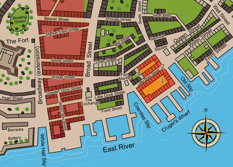
Illustration 27: The Map of the Fire of 1778
The 1778 fire began August 3 at 1:00 AM near the Old Slip end of Cruger's Wharf - (1) above. It swept away the houses, warehouses, and stores along the water while also burning the rest of the block including one side of Little Dock Street. It jumped over the street to ignite the other side of Little Dock (2) and burned down most of that block until it was stopped a few buildings short of the Fish Market (3). It destroyed 64 houses, several warehouses and stores, and three ships near the wharf, a property and inventory loss estimated at Ł250,000 ($40 million in 21st century) -- other than the fire in 1776, New York's most destructive fire to date. See below for references and discussion of map details.
Discussion of map:
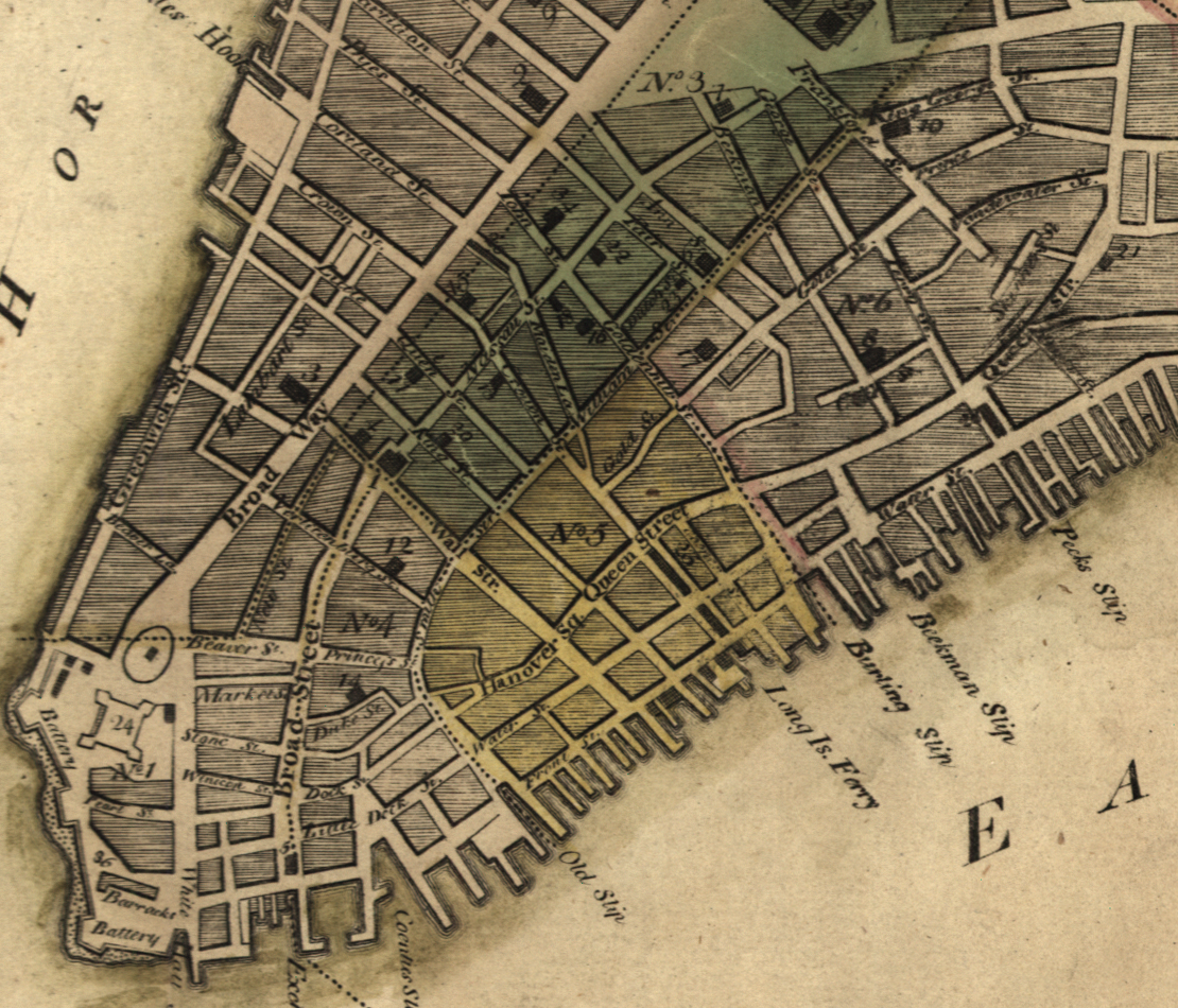
This Map is based the David Grim Map at the New York Historical Society done in the early 19th century 30+ years after the events as seen in Appendix #23. Grim may have used earlier maps for the Appendix #23 version, that is, maps before 1776. We have here in Illustration 27 "updated" the Grim Map along the East River with more "modern" maps (from 1776 through the 1780s) to depict the continuing development of the dock area along the East River, particularly around Cruger's Wharf where the Fire of 1778 took place.
Notably the Holland Map (as reproduced in Cohen and Augustyn, see references below) of 1776 shows the extension of docks at Front Street just north of Broad Street, east of the Exchange. Coenties Slip has a small projection at Front Street and the Little Dock Street bridge over the Coenties is gone. Cruger's Wharf itself has several docks not seen in Grim and perhaps 60% of Old Slip has been filled in at its northern edge.
Other depictions of the East River dock area around Cruger's Wharf from British Headquarters Maps later in the war confirm the continuing development. One from 1782 (Cohen and Augustyn, page 85) shows essentially the same detail of docks as in the Holland Map and Illustration 27. It also suggests the land-fill north of Old Slip has been completed and buildings have been built. However, the area clearly delineated in the Holland Map as being obliterated by the 1776 Fire had not been built up, so the red blocks in this Headquarters Map and others below are thus illustrating street blocks and not necessarily blocks of buildings.
Another British Headquarters map 1782 published by B.F. Stevens (see reference below) also does not distinguish between street blocks and blocks with actual buildings although it does depict how Cruger’s Wharf was restored after the Fire of 1778, three smaller blocks replaced the one longer one. It also shows greater detail of how the dock area north of Old Slip was evolving. The filling in of Old Slip itself seems to have stopped after 1778 at least for a decade or so as evidenced by the McComb-Tiebout Map of 1789 (see reference below).
Note that in most references the number of houses burnt in the fire in 1778 was 64. The Grim Map shows much fewer burnt. Those of us who counted the houses on Grim's Map to estimate the number of houses burnt in 1776 should take his estimates of house/lots with a few grains of pink sea salt since he might not have remembered everything with the accuracy he claimed.
References for 1778 Fire:
- David Grim, Map of New York Fire of 1776, presented to the New-York Historical Society. Grim, David, 1737-1826 M25.1.6 Non-circulating New-York Historical Society; Maps; M25.1.6
- Cohen and Augustyn, Manhattan in Maps 1527-1995 (New York: Rizzoli International Publications, Inc. 1997) pages 83 and 85.
 Stevens' Headquarters Map 1782 (detail) - Lionel Pincus and Princess Firyal Map Division, The New York Public Library. "Facsimile of the unpublished British head quarters coloured manuscript map of New York & environs" The New York Public Library Digital Collections. 1900. https://digitalcollections.nypl.org/items/66592122-d4c5-198f-e040-e00a18066fc1
 McComb-Tiebout Map 1789 (detail) - Mccomb, John, and Cornelius Tiebout. Plan of the city of New York. [New York?, 1789] Map. Retrieved from the Library of Congress, www.loc.gov/item/74692119/
- New York City: New York Gazette and the Weekly Mercury, 8/10/1778, Issue 1399 page 3.
- Poughkeepsie, NY: New York Journal, or, General Advertiser, 8/10/1778 (p2); 8/24/1778 (p2)
- Stokes, Iconography of Manhattan Island, volume 5 - page 1072 who also referenced Montressor's Journal, p508 and Valentine Manual of the Common Council. (1866) p768.
- Online conversions: https://www.uwyo.edu/numimage/currency.htm -- multiple of 161 (pounds 1778 to dollars 2018).