Appendix #8: A Map of New York City Wards (References)
(Click here for links to 1695 spreadsheets or 1703 spreadsheets)
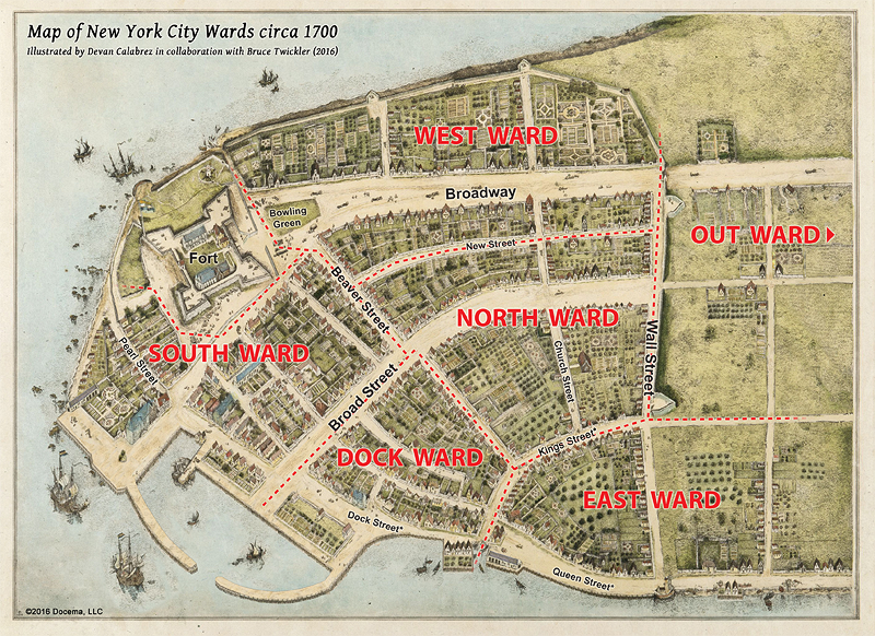
Illustration 8: A Map of New York City Wards circa 1700
In 1683 the city was organized into six wards, which formed the basis of municipal administration including the selection of aldermen, assessors, and constables. The Dongan Charter of 1686 formally approved the wards and the form of municipal government. By 1700 every ward had two fire wardens who inspected chimneys and assessed fines for deficient hearths or smoke exhausts. By then every household also had at least two buckets for the bucket brigades that supplemented the buckets at commercial bakeries/breweries and the municipal buckets at City Hall.
The map here (compared to the Map from the 1660s of Illustration 6) shows the former canals along Broad Street and Beaver Street filled in. The potential of the canals for firefighting was not lost since many wells were dug in the filled-in streets. It also shows for the first time the layout of streets beyond the Wall. By 1695 the Wall itself was dismantled along the northern part of the East Ward. As the wall continued to be removed, the boundaries and even the wards themselves would shift north over the next decades. The Out Ward at the time included precincts of Harlem and the Bowery.
The houses depicted here correspond to those on the original Castello Map plus plausible additions based on the Tax Lists and 1703 Census. Although not street by street accurate they do correspond to the population and households in each of the Wards. The names of streets themselves evolved overtime. The streets with asterisks in the map above include those whose names were eliminated or reapplied. We have used those names here as they were used on the Miller Map of 1695. (see below)
Appendix #8: References for Map of New York City Wards circa 1700
A. Written References
1. From: Collections of the New-York Historical Society for the Year 1910 (New York: Printed for the Society MDCCCCXI), "Prefatory Note." preceding pages of "Contents." from 1-407.
"Prefatory Note... At a meeting of the Common Council held December 8th, 1683. The City and Corporation of New York was divided into six wards as follows:
THE SOUTH WARD
To begin att ye Corner house of James Mathews by ye Watter Side and so North ward along the heere Graft to ye house of Simon Jonson Romain and from thence West ward up ye Beaver graft to ye Corner House of Barent Coursen and from thence south ward by ye forte to ye watter syde including ye Pearle street & so to ye house of James Mathews againe.
DOCK WARD
To Begin att ye house of Mr. Steph: van Courtlandt by ye Watter syde and so North wards to ye Corner house of Geesie Denys from thence east wards to ye house of David Provost and from thence to ye house of Tryntie Clox [Clocke] and so West wards to Mr. Courtlandts againe.
EAST WARD
To Begin att ye house of Thomas Lewis and from thence Northward to ye house of Laurence Sluys then along ye Wall to ye Corner house of Miriam Levy and so to Thomas Lewis againe, with all ye houses in ye Smith floye and without ye Gate on ye South side of ye fresh Watter.
NORTH WARD
To Begin att ye house of Ariane Jonson Hageneer thence east Wards along ye beaver Graft & prince Streete to ye house of Christian Laurier and so Northwards to ye house of Garret Hendrix and from thence West Wards to ye Corner of ye New Streete and thence Southwards to Ariane Johnsons againe.
WEST WARD
To Begin att ye house of Thomas Coker so N: Wards to ye Gate and from thence East Wards along ye Wall to ye Corner of ye New streets thence Southwards to ye house of Peter Brestede and from thence Westwards to ye Widdow of Jo. Johnson Brestede and so to Thomas Cokers againe.
OUT WARD
To Containe ye Towne of Harlem with all ye farmes Plantations and settlemts. on this Island Manhatans from ye North Side of ye fresh Watter.
THE BOWERY PRECINCT mentioned in the tax lists included the Bowery and extended North as far as the present Gramercy Park.
"Mr. William S. Pelletreau from his manuscript notes on early deeds of Manhattan Island, locates the houses mentioned in the respective ward boundaries as follows:
SOUTH WARD
- The house of James Mathews, "Inn Keeper", was the North West corner of what is now Pearl and Broad St.
- The House of Symon Jansen Romaine, was the West corner of Beaver and Broad Street. South side of Beaver Street. (Mentioned in deed 1658)
- Barent Coursen's house was the South corner of Beaver and Whitehall Streets. (Mentioned in old deed)
DOCK WARD
- The house of Stephen Van Cortlandt, was the North East corner of Pearl and Broad Streets, his ownership of a wide lot there, gave him a preemption right to the lots opposite on which Fraunces Tavern was afterwards erected.
- The house of Widow Geesis Denys was the North corner of Broad and Prince Street. (Now Beaver Street East of Broad). Mentioned in old mortgage.
- The house of David Provoost was probably the North West corner of Prince (Beaver) and William St.
- The house of Tryntie Clox (Clocke) is No. 65 Pearl St., North corner of Pearl St., and Hanover Square. The Grace Building was part of her lot.
EAST WARD
- The house of Thomas Lewis was the North West corner of Hanover Square and William Street. (Old Burgers Path)
- The House of Lawrence Sluys was No. 49 Wall St., near to the South East corner of William and Wall Streets. The corner seems to have been at that time a vacant lot.
- The house of Miriam Levi (or Levy) was the South West corner of Pearl and Wall Streets. The Smiths Vly was Pearl Street. (Mentioned in old deeds.)
NORTH WARD
- The house of Arian Jansen Hageneer was the North East corner of Beaver Street and New Street.
- The house of Christian Laurier was the North corner of Prince (Beaver) Street and William Street.
- The house of Garret Hendrix, was the South West corner of Wall and William St.
WEST WARD
- The house of Thomas Coker was the north corner of Beaver and Whitehall St.
- The house of Peter Brestede was on a large lot on the North West corner of Beaver and New Street.
- The Widow of Jan Jansen Brestede had a lot about half way between New Street and Whitehall."
2. From: Stone, William L., HISTORY OF NEW YORK CITY (E. Cleave: New York. 1868) page 71 "On the 8th of December, 1683, the city was divided into six wards.
The First or South Ward, beginning at the river, extended along the west side of Broad to Beaver street ; thence westward along Beaver street to the Bowling Green ; thence southward by the fort to Pearl street ; and thence westward along the river-shore to the place of starting.
The Second or Dock Ward, also beginning at the river at the southeast corner of Pearl and Broad streets, extended along the shore to Hanover Square ; thence northward through William to Beaver street ; thence along Beaver to Broad street; thence back through Broad to the river-shore.
The Third or East Ward formed a sort of triangle, beginning at the corner of Pearl and Hanover Square, and extending along the shore to the Half- Moon Fort at the foot of Wall street ; thence stretching along Wall to the corner of William, and thence returning along the east side of William to the river.
The Fourth or North Ward, beginning at the northwest -corner of William and Beaver streets, extended through the former to the corner of Wall ; thence westerly along the palisades to a line a little beyond Nassau street ; thence southerly to Beaver street ; thence easterly along Beaver to the first-named point.
The Fifth or West Ward, beginning at the junction of the Fourth Ward with Beaver street, extended northerly along the boundary line of the latter to Wall street ; thence along the palisades to Broadway ; thence southerly to Beaver street ; thence easterly to the point of starting.
The Sixth or Out Ward comprised all the farms and plantations outside the city walls, including the Town of Harlem.
Each of these wards was authorized to elect an alderman and councilman annually to represent them in the city government."
3. Descriptions of 1 & 2 interpreted and applied to Illustration 6.
First or South Ward...
- Its eastern boundary started at the water and went up heere Graft (the canal/ditch which became the center of Broad Street when it was filled in). Thus, as Stone indicates, this included the houses on the west side of Broad up to Beaver Street but not the houses on the east side of Broad which belonged to Dock Ward.
- The northern boundary of South ward is the center of Beaver Street, which was indicated above as Beaver Graft (a canal also later filled in). Thus, the houses on the south side of Beaver are included in the South Ward but not the houses on the north side of Beaver which belonged to either North Ward or to West Ward (New Street separating those two wards).
- The western boundary went south 'by the fort' but also included the houses south of the fort on Pearl Street, which were included in both the 1677 and 1695 Tax Lists. By 1695 houses in the block southwest of the fort had been cleared by Governor Colve to provide a wider field of fire for the artillery in the fort. Thus the western boundary went a little south of the fort and then angled to the west for a block and then angled back south to the river.
- The southern boundary was along the water back to Broad Street where it had originated.
Second or Dock Ward...
- The south/eastern lower boundary was along the water from the intersection of William and Dock Streets to Broad Street.
- The western boundary was the east side of Broad Street from the water to its intersection with the extension of Beaver Street (earlier called Princes Street east of Broad).
- The northwestern boundary was the extension of Beaver Street (Princes Street) from Broad to William Street.
- The northeastern boundary was William Street (formerly called Smith Street) from Beaver to Hanover Square. Of note... Stone's description of the East Ward has its northern and western boundaries "...along Wall to the corner of William, and thence returning along the east side of William to the river." This implies that the western side of William was in the Dock and North Wards.
Third or East Ward...
- The south/western boundary was William Street from Hanover Square to the Wall. As indicated above Stone designated the eastern side of William Street to be in the East Ward. The reason that this is relevant is that the original description had the northwest corner of the boundary at "ye house of Laurence Sluys", later No. 49 Wall Street, which is west of the intersection of Williams and Wall Street (see IN Phelps Stokes Iconography of Manhattan Island Volume II plate 82e, page 286). It could be that since the actual southwest corner (taxed as a vacant lot at the time ward boundaries were set up) was a vacant lot, the boundary mavens originally just listed the most notable house near that intersection. In any case, we have adopted Stone's description and shown Williams as the boundary between North and East wards from Beaver to Wall Street.
- The northern boundary was along the wall but the East Ward always included "Smith's Fly" outside 'the gate' (and wall) while there was a gate and wall. By 1700 some of the easternmost section of the wall had been removed as shown in Illustration 6.
- The eastern boundary was along the East River that the Miller Map designated Queen Street in 1695 that later became Pearl Street.
Fourth or North Ward...
- The southern boundary was along Beaver Street from Williams to New Street. Here the designation of Mr. William S. Pelletreau is helpful as he specifies New Street and the northeast corner of Beaver and New Street as the boundary. Stone is a little too coy with "..westerly along the palisades to a line a little beyond Nassau street..." without mentioning the street (New Street) that formed the boundary, which was in fact the line a little beyond Nassau, which itself was sort of the 'extension' of Broad Street on the other side of the wall.
- The western boundary was New Street, which was a pretty new street at the time.
- The northern boundary was the wall from New to Williams Street. There were a few houses outside the wall on Nassau Street by the time of the Miller Map that would eventually be included in the North Ward as the houses outside the wall to the east were included in the East Ward and the houses to the west were included in the West Ward.
- The eastern boundary was William Street between the Wall and Beaver Street.
Fifth or West Ward...
- The southern boundary was Beaver Street from New Street to Bowling Green, across the lower extension of Broadway, and eventually to the Hudson River.
- The western boundary was originally specified as Broadway itself since at the time there were few houses west of Broadway. Every tax list included both sides of Broadway in the West Ward and eventually the houses to the west of Broadway to the Hudson.
- The northern boundary was the palisade (Wall), which was still intact there in the 1680s. However, the West Ward like the East Ward also included houses on or near Broadway outside the wall.
- The eastern boundary was New Street from Wall Street to Beaver. The original description named the boundary of the street "....Wall to ye Corner of ye New streets thence Southwards..." but once again for some inexplicable reason, Stone doesn't call out New Street "...extended northerly along the boundary line of the latter to Wall street..." substituting "boundary line" for New Street. We have used the original designation of New Street as the boundary here.
- As further evidence that New Street continued to be a boundary: Selyn's List of the Dutch Church Members in 1686 (Valentine, History of the City of New York (New York: Putnam & Co, 1853), page 335) names 12 families on New Street, three of which are identifiable in the 1695 Tax List as being in the North Ward (Koning, Kerner or Kermer, and Frederiksen) while three easily identifiable names are in the West Ward (van Gelder, Roome, and Nagel). It was also used as a boundary in later maps (Bradford... see below).
Sixth or Out Ward...
- The Out Ward is indicated but not shown on Illustration 6 since the principal districts or precincts, Harlem and the Bowery, lie to the north of the area depicted by the illustration. Originally intended to include "...all the farms and plantations outside the city wall" most people lived in the Bowery or Harlem. But, as mentioned above, by 1700 the East and West Wards also included properties outside the wall.
B. Map References
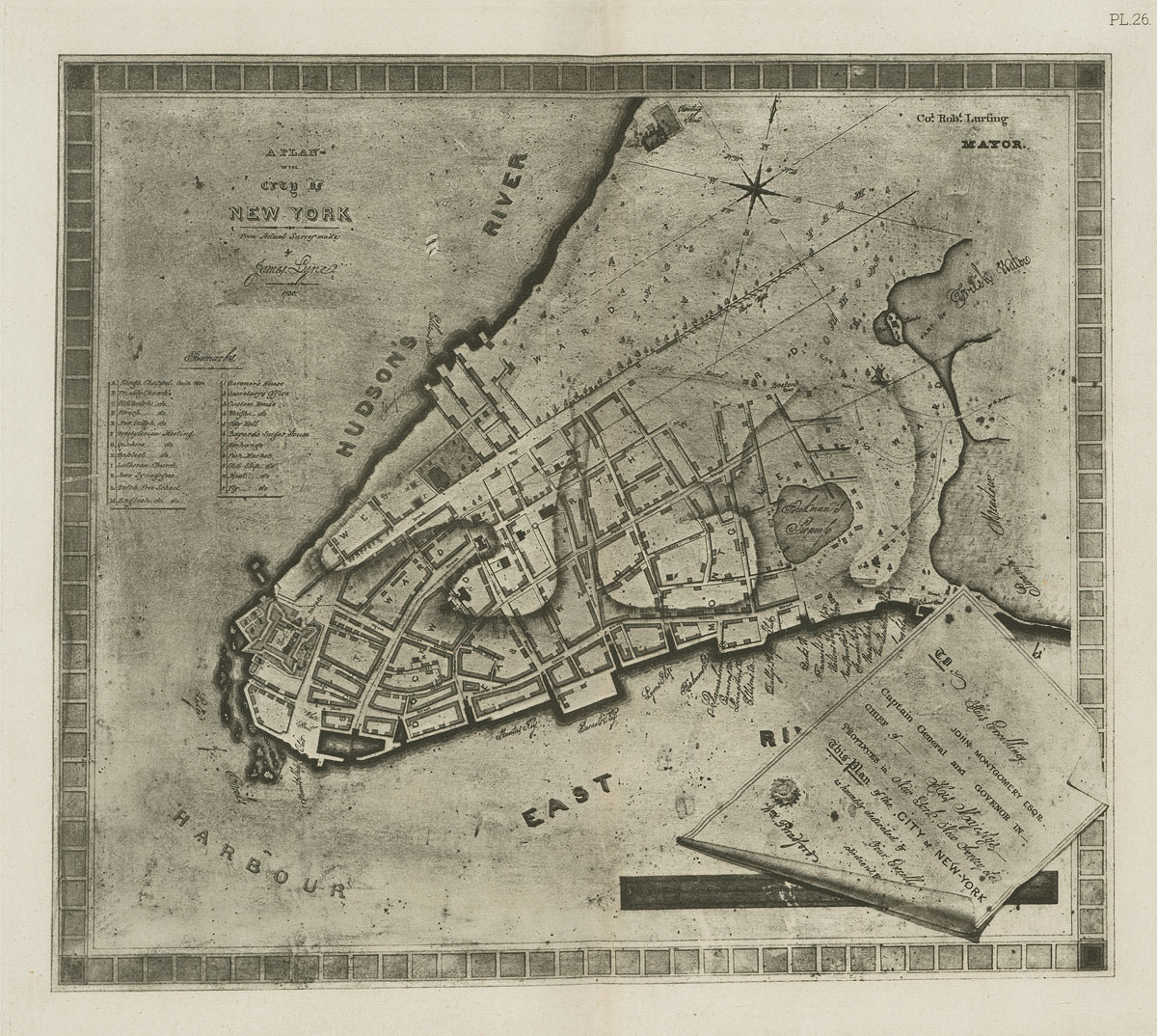
The Map of Illustration 6 used as its references the Stokes, Redraft of the Castello Plan New Amsterdam in 1660 (1916), New Yorke the Miller Plan (1696), and the Bradford Map (1731). These maps can be viewed in hi-res by clicking the map thumbnails below.
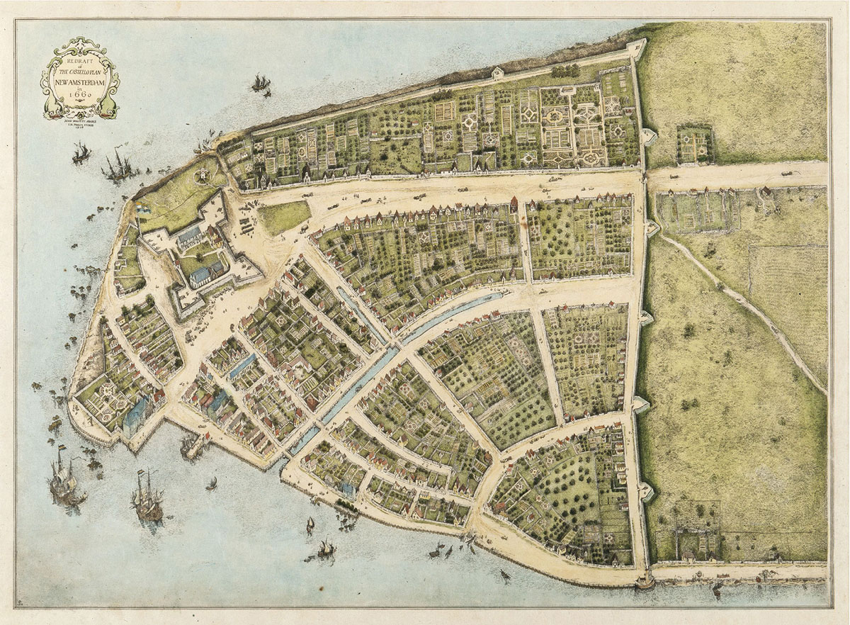
- The Stokes Redraft (1916) was a comprehensive recreation of the original Castello Map (1665... see Map of Illustration #4 showing the Distribution of Fire Buckets) using in addition to the pictorial evidence of the original map the census and survey data compiled contemporaneously with the map. Its proportions and locations of major features are precise including over three hundred houses on the plots of the early Dutch Grants. Illustration 6 used it as a template for the layout of streets and the positioning of major buildings. It also used it as the basis for the "artistic additions" to the houses from later census data in 1695.
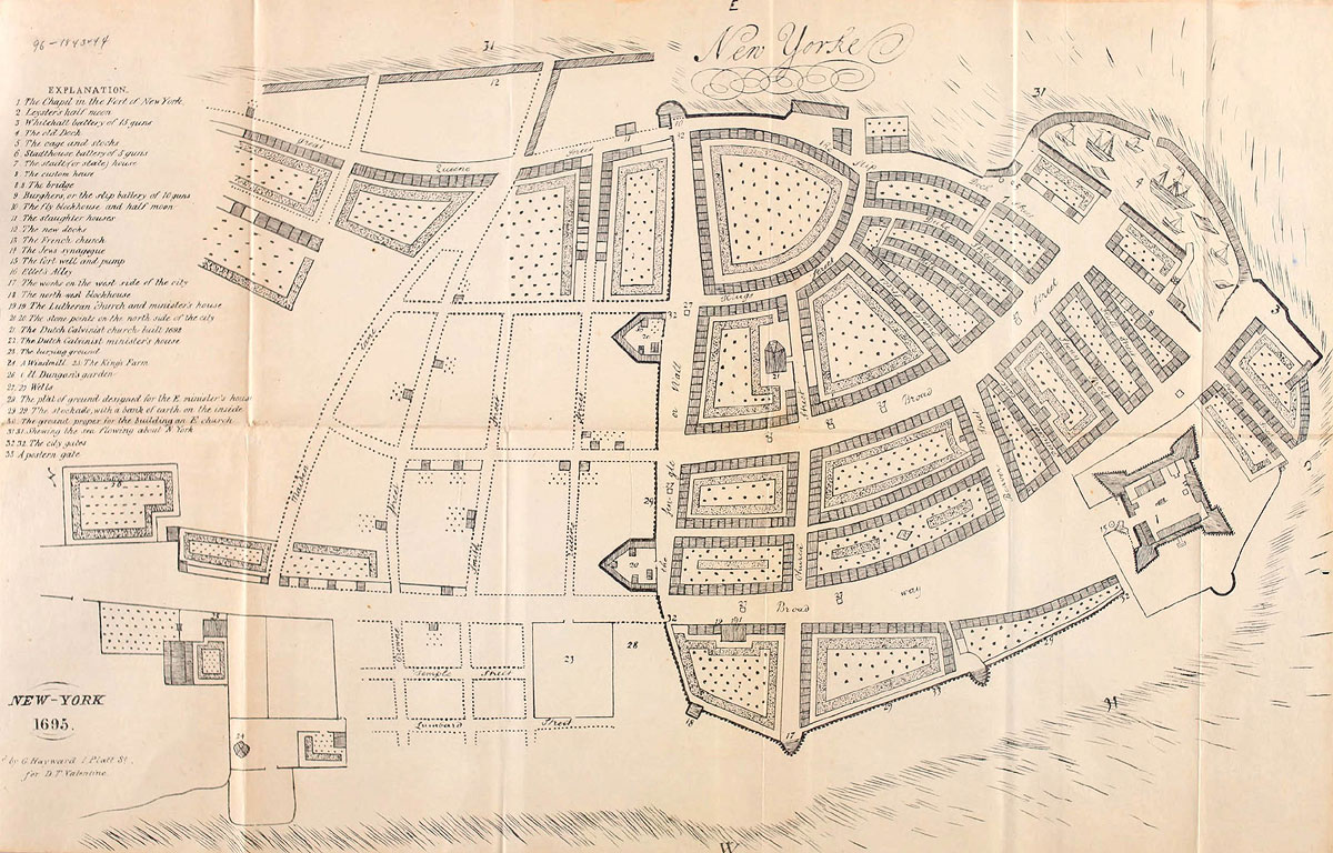
- The Miller Plan while not as precise in some respects as the Stokes Redraft, does provide a view of the 'new' docks along the east River, the northern fortifications (some already disassembled to the east), the creation of new streets like "New Street" and "Queen Street", and a "projection" of house lots around 1695. It also gives a view of how the city is expanding to the north including the street layouts and some developed features such as houses and gardens. As mentioned in the caption to Illustration 6, the street names used there were transcribed from the Miller Plan.
The Miller Plan illustrates "house lots" but not houses. The Plan shows about 900 individual lots (875 by one count of the lower five wards), which is almost twice the number of houses (483 for the lower five wards) listed in the 1695 Tax List. Illustration 6 shows a more likely number of houses based on "Appendix #8: Estimate of Housing Distribution" below. - The Lyne-Bradford Plan was a useful reference for seeing how the city evolved from 1700 including waterfront development, new streets, new street names, and, critical to the future management of the city: the reorganization of the wards. After the Montgomery Charter, the Bradford Map showed the new ward boundaries and the addition of a new ward, the Montgomerie ward northeast of the city. It also partially illustrates the houses built by ward on the house lots shown in the Miller map. Other later maps (Buchnerd and Grim) informed the distribution of houses by ward as pictured in Illustration 6. However, Illustration 6 relied mostly on the "Appendix #8: Estimate of Housing Distribution" below as it was derived from does the comprehensive Tax list of 1695 and the Census of 1703.